New features (as of November 1st, 2006))
Drawing Tools: The path and polygon drawing tools are now available in the free product. You can easily sketch figures on the imagery for richer annotations and can share these overlays as KML or KMZ files. These features can be accessed from the toolbar.
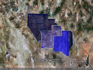
These screenshots are examples of 3D buildings created using the drawing tools.
Premium modules are now free with the Google Earth Pro subscription. Click here to read more

- Premium Printing Module: print high-resolution images up to 11" x 17" (4800 pixels) sample print (890k)
- GIS Data Importing Module: incorporate GIS data in file formats such as .shp, .tab. Examples include parcel data, demographics data, 3D building data
- Movie Making Module: export compressed movies (.wmv) of zooms and tours sample movie (13M).
Faster performance for 3D models
- Improved caching of models
- Support for compressed textures
New icons and icon management for easier navigation
- New icons for pushpins and user palette
- Coincident placemarks/icons now expand into a 憇tar-formation for disambiguation when you click on them.
Improved Printing: Now you can also print search results, and folders of placemarks, in addition to driving directions and the 3D view.
MSI Installer: For easier installation and maintenance of Google Earth over networks, we now have an MSI installer available for the client.
下载:Google Earth (Release 4 - BETA)